|
|
|
|
Technical Information |
|
TABLE OF CONTENTS After-Action Report: Appendix 2: Appendix 3: Complete Report
|
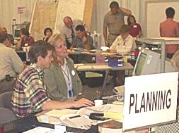
Summary: GIS, hydrology, ARES/RACES river monitor readings, and interaction with PacifiCorp representatives injected an additional and stimulating layer of realism into the exercise. Some simulated data did not correlate with "real-world" findings. Hydrology models were less than optimal for this type of prediction. Printing for GIS was slow, and maps were small and not distributed to everyone who might have benefited from them. These discoveries will enhance future modeling and treatment of real flooding situations. The technical advisors present for the exercise served as both simulators and players. GIS and hydrology experts collected information and utilized computer programs to generate predictions or graphic portrayals of the emergency. GIS created maps and population estimates for evacuation zones. Hydrology predicted river levels for the long-range planning portion of the exercise. ARES/RACES volunteers monitored the remote river sensors and fielded simulated radio reports from amateur radio operators regarding other stream levels. The information generated by these technical personnel was regarded as extremely valuable by the Planning and Operations sections. The sections were also surprised by the amount of time it takes to produce the results and reports.
GIS noted that plotting a single elevation value to determine inundation areas for the entire county is not realistic or useful, as different areas with different elevations are not accurately represented. Mapping for different drainage basins and river zones would need to be modified. Maps were not seen by all participants, though, and others besides law enforcement and fire indicated that they would have found this resource helpful as well. This is a resource which needs to be utilized more within the ECC. Our technical understanding of flooding has been greatly enhanced by this exercise, as has our awareness of available flood management resources. See recommendations related to Technical Information and Electronic Systems, return to Summary, or use the links below to view more detailed findings. View more: |
|
For further information/discussion on this report, please call (360) 737-1911 to speak with Deborah Needham (Ext. 3962) or John Wheeler (Ext. 3941) at Clark Regional Communications Agency. E-mail comments to deborah.needham@co.clark.wa.us. Click here to view the main web page. |